
Landsat 9: The Planet’s Changing Landscape with Precision
The Landsat 9 mission, a joint initiative by NASA and USGS, continues the legacy of Earth observation, providing high-resolution satellite imagery for climate monitoring, resource management, and disaster response. With cutting-edge OLI-2 and TIRS-2 sensors, Landsat 9 enhances land cover analysis, water resource assessment, and agricultural monitoring. This article explores its technical capabilities, key objectives, sustainability contributions, and future advancements, highlighting its role in global environmental research.
SPACE MISSIONISRO/NASAEDUCATION/KNOWLEDGESPACE/TECH
Sachin K Chaurasiya
3/28/20255 min read
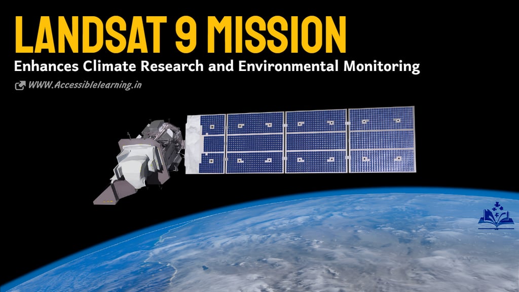

The Landsat 9 mission, a joint effort between NASA and the U.S. Geological Survey (USGS), is a groundbreaking advancement in Earth observation. Launched on September 27, 2021, Landsat 9 continues the nearly 50-year legacy of the Landsat program, providing critical data for environmental monitoring, climate change research, and resource management. This mission enhances our ability to track changes in land use, water resources, and natural disasters, ensuring that scientists, governments, and industries have accurate and up-to-date information.
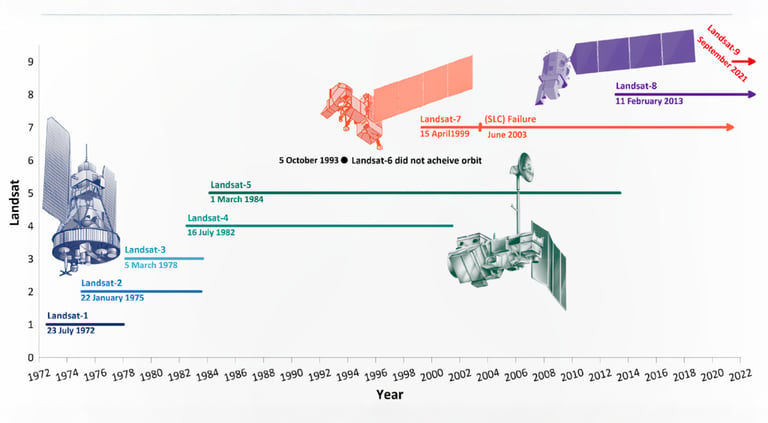
Background and Evolution of Landsat Missions
The Landsat program began in 1972, marking the dawn of satellite-based Earth observation. Over the years, successive Landsat satellites have improved spatial resolution, spectral capabilities, and imaging frequency. Each new mission built upon its predecessor, offering more refined data. Landsat 9, developed as a successor to Landsat 8, strengthens global efforts to understand environmental changes with improved technology and reliability.
Technical Capabilities of Landsat 9
Landsat 9 is equipped with two state-of-the-art instruments:
Operational Land Imager 2 (OLI-2): This instrument captures images in nine spectral bands, including visible, near-infrared, and shortwave infrared. These bands help in detecting vegetation health, water quality, and land cover changes.
Thermal Infrared Sensor 2 (TIRS-2): This sensor measures land surface temperatures using two thermal infrared bands, crucial for studying drought conditions, agricultural irrigation, and urban heat islands.
Additional Technical Specifications
Orbit Altitude: 705 km (sun-synchronous orbit)
Revisit Time: Every 16 days
Orbit Period: 99 minutes per complete orbit
Spatial Resolution: 30 meters (visible and infrared), 100 meters (thermal)
Swath Width: 185 km
Imaging Capacity: Captures up to 750 scenes per day
Communication: Uses the Tracking and Data Relay Satellite System (TDRSS) for data transmission
Key Objectives of Landsat 9
Landsat 9 plays a pivotal role in multiple research domains:
Climate Change Monitoring: By tracking deforestation, glacier retreat, and coastal erosion, the mission provides critical insights into the impact of global warming.
Agriculture and Food Security: Farmers and policymakers use Landsat imagery to monitor crop health, optimize irrigation, and predict yields.
Water Resource Management: The satellite helps assess freshwater availability, detect water pollution, and manage drought-prone areas.
Disaster Response and Recovery: Landsat 9 data assists in assessing damage caused by wildfires, floods, and hurricanes, improving response strategies.
Urban Development and Land Use Planning: City planners leverage satellite imagery to manage urban growth, transportation networks, and environmental sustainability.
Forest and Biodiversity Monitoring: By analyzing changes in forest cover, Landsat 9 supports conservation efforts and biodiversity protection initiatives.
Landsat 9 vs. Previous Missions
While Landsat 9 closely mirrors Landsat 8 in design, it features notable upgrades:
Improved Radiometric Performance: Enhances the detection of subtle differences in land surface conditions.
Reduced Data Gaps: Ensures continuous and more reliable data collection.
Greater Imaging Capacity: Can capture up to 750 scenes per day, an increase from Landsat 8’s 550 scenes per day.
Extended Lifespan: Designed to operate for at least 10 years, ensuring a longer period of data collection.
Role of Landsat 9 in Global Sustainability Efforts
Landsat 9 is integral to various international sustainability programs, including:
United Nations Sustainable Development Goals (SDGs): Supports goals related to climate action, clean water, and sustainable cities.
Paris Climate Agreement: Provides critical data to track carbon emissions and deforestation trends.
Wildlife Conservation Efforts: Helps monitor habitat loss and ecosystem changes in biodiversity hotspots.
Carbon Sequestration Studies: Aids scientists in measuring carbon stored in forests and soil.
Coastal and Marine Ecosystem Studies: Tracks coral reef health, mangrove forests, and oceanic temperature variations.
Data Accessibility and Usage
One of Landsat 9’s most significant contributions is its open data policy. All imagery captured by the satellite is freely available through the USGS Earth Explorer and NASA’s Earthdata portals. This accessibility empowers scientists, researchers, and policymakers worldwide to analyze environmental changes without financial barriers. The data is also used in conjunction with artificial intelligence (AI) and machine learning models to enhance predictive analysis and automate land classification.
Future of Earth Observation with Landsat 9
Landsat 9 strengthens global research and contributes to international climate agreements like the Paris Agreement. The data from this mission is freely available, enabling scientists worldwide to analyze Earth’s changing landscape. Additionally, it lays the foundation for the Landsat Next mission, expected in the 2030s, which will further refine Earth observation capabilities. Future enhancements may include higher spatial resolution, improved spectral coverage, and increased revisit frequency, ensuring even more precise and detailed Earth monitoring.
FAQ
What is the Landsat 9 mission?
Landsat 9 is an Earth observation satellite launched by NASA and the U.S. Geological Survey (USGS) on September 27, 2021. It continues the Landsat program’s legacy of providing high-resolution satellite imagery for environmental monitoring, land-use analysis, climate change research, and resource management.
What are the key instruments onboard Landsat 9?
Operational Land Imager 2 (OLI-2): Captures high-resolution images in nine spectral bands, including visible, near-infrared, and shortwave infrared.
Thermal Infrared Sensor 2 (TIRS-2): Measures land surface temperatures using two thermal infrared bands, crucial for studying climate patterns, droughts, and urban heat islands.
How does Landsat 9 differ from Landsat 8?
Improved radiometric performance for detecting subtle land changes.
Higher imaging capacity, capturing up to 750 scenes per day (compared to Landsat 8’s 550 scenes).
Extended mission lifespan of at least 10 years.
What is Landsat 9’s orbit and coverage area?
Landsat 9 orbits Earth at 705 km (438 miles) in a sun-synchronous orbit, ensuring consistent lighting conditions. It revisits the same location every 16 days, providing regular updates for environmental monitoring. Each image covers a 185 km (115 miles) wide swath of the Earth's surface.
How does Landsat 9 contribute to climate change research?
Landsat 9 helps track deforestation, glacier retreat, coastal erosion, and carbon storage in forests, providing critical data for understanding climate change. It supports international efforts like the Paris Climate Agreement and United Nations Sustainable Development Goals (SDGs).
How can researchers and the public access Landsat 9 data?
Landsat 9 follows an open data policy, meaning all its imagery is freely available through platforms like:
USGS Earth Explorer (https://earthexplorer.usgs.gov/)
NASA’s Earthdata portal (https://earthdata.nasa.gov/)
What are some real-world applications of Landsat 9?
Agriculture: Monitoring crop health and optimizing irrigation.
Water Resource Management: Assessing freshwater availability and detecting pollution.
Disaster Response: Tracking wildfires, floods, and hurricanes for better emergency planning.
Urban Planning: Managing city expansion and monitoring environmental sustainability.
Forestry and Biodiversity: Analyzing deforestation, habitat loss, and ecosystem changes.
What is the future of Landsat missions after Landsat 9?
NASA and USGS are planning the Landsat Next mission, expected in the 2030s, which will feature higher resolution, more spectral bands, and increased imaging frequency, further improving Earth observation capabilities.
The Landsat 9 mission is a monumental step in Earth observation, ensuring continuity in global environmental monitoring. By delivering high-quality imagery and valuable scientific data, Landsat 9 helps researchers, policymakers, and industries make informed decisions about our planet's future. With climate change and urbanization accelerating, this mission is more important than ever in understanding and preserving Earth's delicate balance. Its impact on agriculture, forestry, water management, and disaster response underscores its invaluable contribution to global sustainability efforts.
Subscribe To Our Newsletter
All © Copyright reserved by Accessible-Learning Hub
| Terms & Conditions
Knowledge is power. Learn with Us. 📚

