
Deep Space Climate Observatory (DSCOVR): A Comprehensive Technical Insight
Discover the Deep Space Climate Observatory (DSCOVR), a critical satellite for space weather forecasting and climate monitoring. Learn about its mission, technical specifications, scientific instruments, and key contributions to solar wind detection and Earth observation.
SPACE MISSIONEDUCATION/KNOWLEDGESPACE/TECHISRO/NASA
Sachin K Chaurasiya
3/27/20255 min read
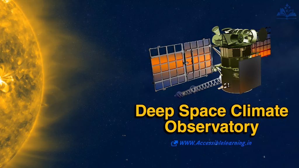
The Deep Space Climate Observatory (DSCOVR) is a multi-purpose deep-space satellite designed to monitor both space weather and Earth’s climate. Positioned at Lagrange Point 1 (L1), approximately 1.5 million km (932,000 miles) from Earth, DSCOVR plays a critical role in early-warning systems for geomagnetic storms and long-term climate monitoring.
Originally conceived as Triana, a mission to provide a continuous Earth image, the satellite was repurposed and launched in 2015 by NOAA, NASA, and the U.S. Air Force. It has since become a key asset for monitoring solar wind activity, space weather hazards, and Earth's radiation balance.
This article provides an in-depth technical overview of DSCOVR, including its mission goals, instrumentation, data processing capabilities, and operational significance.
DSCOVR Mission Overview
1.1 Mission Objectives
DSCOVR’s primary goals are:
Space Weather Monitoring: Provides real-time solar wind data to predict geomagnetic storms and their effects on Earth.
Earth Observation: Captures climate-related data, including Earth’s energy balance, ozone levels, cloud cover, and air pollution.
Full-Disk Imaging: Offers a continuous view of Earth’s sunlit side for climate and atmospheric studies.
1.2 Key Collaborators and Responsibilities
NOAA: Manages the space weather forecasting aspects.
NASA: Handles Earth observation and mission support.
U.S. Air Force: Assisted in launch operations and ongoing communications support.
1.3 Launch and Deployment
🚀 Launch Date: February 11, 2015
🚀 Launch Vehicle: SpaceX Falcon 9
🚀 Orbit: Halo orbit at L1 (Lagrange Point 1)
🚀 Operational Life Expectancy: Originally 5 years, but continues to operate effectively beyond its design lifespan.
Technical Architecture of DSCOVR
2.1 Spacecraft Design and Specifications
Satellite Bus: Based on the SMEX-Lite platform.
Mass: ~570 kg (~1,260 lbs).
Dimensions: Approximately 1.37m × 1.87m × 2.15m.
Power Source: Two solar arrays providing 600W of power.
Onboard Memory: 32 Gbit solid-state recorder.
2.2 Communications System
📡 Primary Communication: X-band downlink for high-rate scientific data transmission.
📡 Backup Communication: S-band for command and telemetry.
📡 Data Transmission Rate:
Space weather data: real-time, continuous transmission (NOAA).
Earth observation data: Stored and transmitted in batches to NASA ground stations.
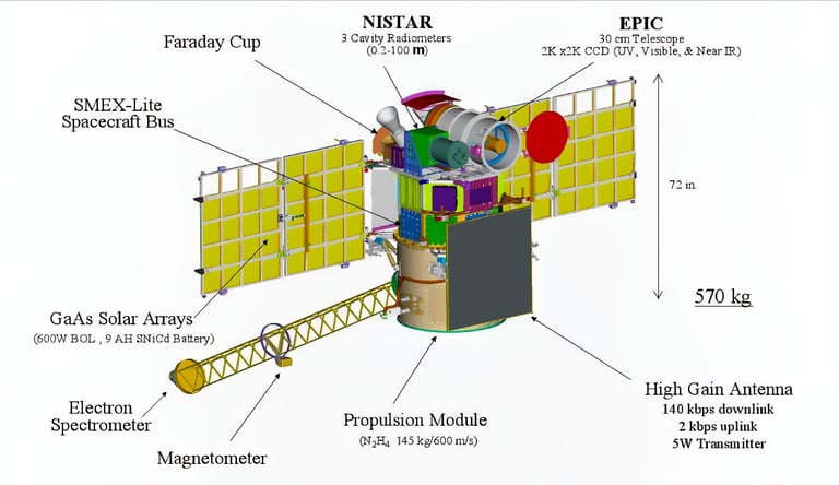
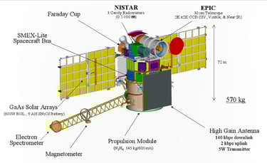
DSCOVR’s Scientific Instruments
3.1 Earth Polychromatic Imaging Camera (EPIC)
📸 Function:
Captures full-disk, multi-spectral images of Earth in 10 UV and visible wavelengths.
Measures aerosols, ozone, cloud height, and vegetation reflectivity.
🛠️ Technical Details:
Field of View (FoV): 0.62°
Resolution: 2048 × 2048 pixels (4 km per pixel at nadir).
Spectral Bands: 317.5–780 nm (UV to visible light).
Image Frequency: Every 2 hours.
🌍 Scientific Applications:
✔️ Tracks ozone concentration and air pollution.
✔️ Monitors cloud motion and Earth’s atmospheric radiation balance.
✔️ Detects volcanic eruptions and wildfires based on aerosol presence.
3.2 National Institute of Standards and Technology Advanced Radiometer (NISTAR)
🌞 Function:
Measures total solar energy reflected and emitted by Earth.
Helps quantify Earth’s radiation budget and climate forcing mechanisms.
🛠️ Technical Details:
Spectral Range: 0.2–100 µm (broadband).
Detector Type: Pyroelectric radiometer.
Data Collection Rate: Every 15 minutes.
🌍 Scientific Applications:
✔️ Tracks global energy imbalance linked to climate change.
✔️ Measures the effects of greenhouse gases on Earth’s heat retention.
✔️ Provides real-time energy flux variations due to seasonal changes.
3.3 Plasma Magnetometer (MAG) and Faraday Cup
☀️ Function:
Monitors solar wind properties to forecast geomagnetic storms.
Detects interplanetary magnetic field (IMF) fluctuations.
🛠️ Technical Details:
MAG: Measures magnetic field strength (±65536 nT range).
Faraday Cup:
Ion energy range: 0.2–20 keV.
Solar wind speed accuracy: ±10 km/s.
🌌 Scientific Applications:
✔️ Provides 15-60 minutes of advance warning for solar storms.
✔️ Helps safeguard satellites, power grids, and communications systems.
✔️ Improves forecasting models for coronal mass ejections (CMEs).

DSCOVR’s Data Processing and Dissemination
Real-Time Space Weather Alerts
NOAA’s Space Weather Prediction Center (SWPC) receives live solar wind data from DSCOVR.
Alerts are issued to NASA, power companies, airlines, and GPS operators.
Climate Monitoring Data
NASA processes EPIC and NISTAR data.
Climate models incorporate this information to study global warming trends.
Public Data Access
DSCOVR’s data is available on NOAA’s and NASA’s open-access platforms.
EPIC images are publicly accessible and often used for educational and research purposes.
Major Contributions and Discoveries
Enhanced Geomagnetic Storm Predictions: Improved forecasting of solar flares and space weather impacts.
Historic Images of Earth and the Moon: Captured rare Earth-Moon transit sequences from deep space.
Air Pollution Mapping: Contributed to studies on global aerosol concentration and climate effects.
New Insights into Earth’s Energy Imbalance: Provided accurate radiative flux measurements, crucial for climate research.
Future of DSCOVR and Successor Missions
Potential Successors
SWFO-L1 (Space Weather Follow-On at L1): Planned NOAA mission for enhanced solar monitoring.
NASA’s PACE (Plankton, Aerosol, Cloud, Ocean Ecosystem): A next-gen satellite for climate studies.
Challenges and Mission Longevity
DSCOVR has exceeded its expected lifespan but remains operational.
Fuel limitations may reduce its ability to maintain orbit at L1 in the coming years.
Planning for replacements or upgrades is ongoing.
Frequently Asked Questions
What is the Deep Space Climate Observatory (DSCOVR)?
DSCOVR is a deep-space satellite designed for space weather monitoring and Earth climate observation. It provides real-time solar wind data for predicting geomagnetic storms and captures images of Earth’s sunlit side to monitor climate changes.
Who operates the DSCOVR satellite?
DSCOVR is a joint mission between:
NOAA (National Oceanic and Atmospheric Administration): Manages space weather forecasting.
NASA (National Aeronautics and Space Administration): Oversees Earth observation and research.
U.S. Air Force: Assisted in the satellite's launch and provides communication support.
Where is DSCOVR located in space?
DSCOVR orbits Lagrange Point 1 (L1), approximately 1.5 million km (932,000 miles) from Earth. This position allows it to provide early warnings of incoming solar storms and capture uninterrupted images of Earth.
What are the main scientific instruments onboard DSCOVR?
DSCOVR has three primary instruments:
EPIC (Earth Polychromatic Imaging Camera): Captures high-resolution images of Earth and monitors climate-related changes.
NISTAR (National Institute of Standards and Technology Advanced Radiometer): Measures Earth’s reflected and emitted radiation to track climate change.
Plasma Magnetometer & Faraday Cup: Monitors solar wind and magnetic field variations to predict space weather impacts.
How does DSCOVR help predict space weather?
DSCOVR continuously measures solar wind speed, density, and magnetic field variations. This data allows NOAA to provide 15-60 minutes of advance warning for geomagnetic storms, helping prevent disruptions to power grids, GPS systems, and satellite communications.
How does DSCOVR contribute to climate monitoring?
DSCOVR’s EPIC and NISTAR instruments monitor Earth’s energy balance, ozone levels, aerosol concentrations, and cloud formations. This data is crucial for studying climate change, global warming, and atmospheric pollution trends.
How often does DSCOVR take pictures of Earth?
The EPIC camera captures full-disk images of Earth every 2 hours. These images are publicly available and provide valuable insights into atmospheric conditions and environmental changes.
What was DSCOVR’s original mission?
DSCOVR was initially called Triana, proposed by NASA in the late 1990s to provide continuous images of Earth. The mission was repurposed in the 2000s for space weather and climate monitoring.
How long will DSCOVR remain operational?
Although DSCOVR was designed for a 5-year mission, it has continued to operate well beyond its expected lifespan. However, fuel limitations may affect its ability to maintain orbit in the coming years. NOAA is planning for successor missions, such as SWFO-L1 (Space Weather Follow-On at L1).
Where can I access DSCOVR’s data and images?
DSCOVR’s data is publicly available through:
NOAA’s Space Weather Prediction Center (SWPC) for real-time solar wind data.
NASA’s EPIC website for full-disk Earth images.
DSCOVR is a cornerstone of deep-space monitoring, bridging the gap between space weather prediction and climate science. Its data helps prevent economic losses from solar storms, supports climate change research, and offers stunning full-disk Earth images.
🚀 With its continued operation, DSCOVR remains a vital tool for safeguarding both our planet and technology-dependent society. 🌍✨
Subscribe To Our Newsletter
All © Copyright reserved by Accessible-Learning Hub
| Terms & Conditions
Knowledge is power. Learn with Us. 📚

